|
More historical maps at |
 |
Weitere historische Karten bei |
|
Germany 1789 interactive
English Version
40 German history maps
ideal for teaching, genealogy and
all people interested
in history
|
Deutschland 1789
Deutsche Version
40 Karten aus der deutschen Geschichte
ideal für Unterrichtszwecke, Familienforschung
und alle,
die sich für Geschichte interessieren
|
|
Demo Version appr.
1,2 MB
-
The Holy Roman Empire of the German Nation
-
Bavaria
-
Bavarian Swabia
-
Baden-Wurttemberg Southern Part
-
Saxony – Thuringia – Anhalt
|
klick to view |
Demoversion ca. 1,2 MB
-
Das Heilige Römische Reich Deutscher Nation
-
Bayern
-
Bayerisch-Schwaben
-
Baden-Württemberg
Südteil
-
Sachsen – Thüringen –
Anhalt
-
Die Navigationsflächen in der Übersichtskarte sind nur für die
Beispielkarten aktiv,
-
ebenso die Navigationspfeile in den Einzelkarten.
|
Karte
anklicken |
|
Full version as pdf-file
-
Direct Download
Price 29 € + tax
-
CD-ROM shipping included
39 €
+ tax
Shipment within 2 days
-
Payment by credit card, bank transfer or cheque.
-
Information:
info@hoeckmann.de
|

 |
Vollversion im pdf-Format
-
Direktes Herunterladen
Preis 19 €
+ Mwst.
-
CD-ROM incl. Versand
29 € + Mwst.
Versand erfolgt innerhalb von 2 Tagen.
-
Bezahlung per Banküberweisung,
Online-Banking, Scheck oder Kreditkarte
-
Bei Fragen:
info@hoeckmann.de
|

 |
|
Contents
of the full version of
Germany 1789
(Links
to sample maps in pdf-quality)
-
The Holy Roman Empire of the German Nation
-
Bavaria
-
Swabia (Bavarian part)
-
Swabia Northern Part
-
Baden-Wurttemberg Southern Part
-
Baden-Wurttemberg Northern Part
-
Palatinate
-
Saarland
-
Rhineland-Palatinate
-
Hesse Southern part
-
Hesse Northern part
-
Saxony - Thuringia – Anhalt
-
Brandenburg
-
Silesia (1763)
-
Pomerania
-
Mecklenburg
-
Schleswig-Holstein (1730)
-
Lower-Saxony
-
South-Western part of Lower Saxony
-
Niederstift Münster
-
Northrhine-Westphalia
-
Bishporic of Cologne
-
Lower Rhineland
-
Bishopric of Münster – Southern part
-
Minden-Ravensberg and Lippe
-
Bishopric of Paderborn and P. of Waldeck
-
Duchy of Westfalen
-
Ruhr area
-
Siegerland
-
East-Prussia and West-Prussia
-
Limburg and Liège
-
Luxemburg
-
Flanders and Brabant
-
Lorraine (1648)
-
Alsace Southern Part (1648)
-
Tyrol (1766)
-
Austria
-
Baltic countries 16. century
-
Baltic countries end of the 17. century
-
Baltic countries end of the 18. century
-
Legend and abbreviations
|
Inhalt der Vollversion von
Deutschland 1789:
(Links zu Beispielen in pdf-Qualität)
-
Das Heilige Römische Reich Deutscher Nation
-
Bayern
-
Bayerisch-Schwaben
-
Schwaben Nord
-
Baden-Württemberg Süd
-
Baden-Württemberg Nord
-
Pfalz
-
Saarland
-
Rheinland-Pfalz
-
Hessen Süd
-
Hessen Nord
-
Sachsen – Thüringen – Anhalt
-
Brandenburg
-
Schlesien (1763)
-
Pommern
-
Mecklenburg
-
Schleswig-Holstein (1730)
-
Niedersachsen
-
Südwest-Niedersachsen
-
Niederstift Münster
-
Nordrhein-Westfalen
-
Kurfürstentum Köln
-
Niederrhein
-
Fürstbistum Münster – Oberstift
-
Minden-Ravensberg und Lippe
-
Fürstbistum Paderborn und Fürstentum Waldeck
-
Herzogtum Westfalen
-
Ruhrgebiet
-
Siegerland
-
Ostpreussen und Westpreussen
-
Limburg und Lüttich
-
Luxemburg
-
Flandern und Brabant
-
Lothringen (1648)
-
Elsass Süd (1648)
-
Tirol (1766)
-
Österreich
-
Baltikum 16. Jahrhundert
-
Baltikum Ende 17. Jahrhundert
-
Baltikum Ende 18. Jahrhundert
-
Legende und Abkürzungen
|
-
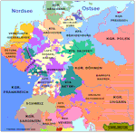
The map of the Empire is interactive. It
allows you to access the wanted map by klicking onto the desired
area.
-
The same goes for the map of
Northrhine-Westphalia.
-
Each map has interactive rims that lead to
the neighbouring map.
-
The navigation arrows also lead to the
neighbouring maps.
-
By using the functions of the Acrobat Readers©
you can display a list of the maps and a table of contents that also
allow navigation.
-
The maps can be printed in different sizes
dependent on your printer. They were optimized for the A3 size (11
1/2" x 16 1/2")
-
Of course you can use the zoom function of
the Acrobat Reader©.
-
All maps are of much higher quality than the
gif-format maps on the internet.(see the demo version)
|
-
Über die Einstiegskarte
Das Heilige Römische Reich Deutscher Nation 1789 können
Sie per Klick direkt in die gewünschte Karte springen.
-
Gleiches gilt für die Karte Nordrhein-Westfalens.
-
Jede Karte verfügt über aktive Bereiche an den Rändern, die in
die benachbarten Karten führen.
-
Über Navigationspfeile gelangen Sie ebenfalls in die
benachbarten Karten.
-
Über die Funktionen des Acrobat Readers©
können auch mit der Seitenliste oder der Gliederung navigieren.
-
Die Karten lassen sich in verschiedenen
Größen abhängig von Ihrem Drucker ausdrucken.
Sie wurden für die Größe A3 optimiert (Schriftgröße)
-
Am Bildschirm können Sie natürlich die
Zoomfunktion des Acrobat Readers©
nutzen.
-
Die Karten sind von
deutlich höherer Qualität als die im Internet veröffentlichten gif-Karten (siehe Demo-Version).
|
|
Note:
-
These
maps show the territorial situation in Germany in 1789.
-
We have
now the year 2006 – the Holy Roman Empire of the German Nation
ceased to exist 200 years ago.
The maps were not drawn to show any territorial claims or demands.
-
The maps
may be used for private and educational purposes.
None of the maps may be used for any printed or electronic
publication without written permission.
-
©
Copyright 2006 by Thomas Höckmann.
-
For
further information please contact:
info@hoeckmann.de
|
Hinweise:
-
Die abgebildeten Karten stellen die territoriale Situation im
Jahre 1789 in Deutschland dar.
-
Wir schreiben heute das Jahr 2006 – vor 200 Jahren wurde das Heilige
Römische Reich der Deutschen Nation aufgelöst. Irgendwelche
territorialen Ansprüche oder Forderungen sollen diese Karten nicht
dokumentieren.
-
Die Karten dürfen für den Privatgebrauch oder für
Unterrichtszwecke genutzt werden. Das Kopieren der Karten für die
Veröffentlichung in Aufsätzen, Büchern usw. unterliegt der
ausdrücklichen Genehmigung des Verfassers.
-
Gleiches gilt für die Veröffentlichung im Internet.
-
Das Copyright liegt bei Thomas Höckmann.
-
Bei Fragen schicken Sie bitte eine Mail an:
info@hoeckmann.de
|