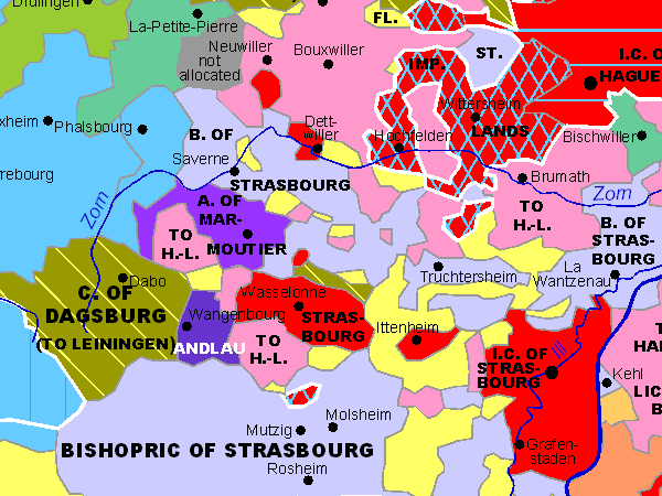
Sample of the Interactive Map Alsace-Lorraine 1648
Ausschnitt der interaktiven Karte Elsass-Lothringen 1648
Exemple de la carte interactive Alsace-Lorraine 1648
List of maps

Sample map

Germany

Baden-Württemberg South

Baden-Württemberg North

Bavaria

Bavarian Swabia

Swabia North

Brandenburg

Hesse North

Hesse South

Mecklenburg

Lower Saxony

Northrhine-Westphalia

Palatinate

Pomerania

West and East-Prussia

Rhineland-Palatinate

Saarland

Saxony

Silesia

Schleswig-Holstein

Thuringia

Limburg

Luxembourg

Flanders

Lorraine

Alsace South

Tyrol

Austria

Baltic Countries

© Thomas Höckmann

External Links

Thuringia

Germany

Netherlands

Switzerland

Sitemap

Abbreviations

recommended books

Start/Home

these pages deal with history - not with chauvinism or territorial claims

  • 40 interactive maps show the Holy Roman Empire of German Nation
  • direct link to the relevant articles in Wikipedia
  • excellent pdf-quality (better than the above shown gif-version)
  • zooming function
  • the maps have differnt scales
  • direct download for only 29 Euro + taxes
  • more
 

this map and 39 more:
Germany 1789 - an interactive atlasEnglish Version
you always wanted to know
where your ancestors came from?
who owned which part of Germany?
more

Periodical Historical
Atlas of Europe
English Version

21 Maps of Europe
one for each Century - more

Historical Atlas box

Startseite

info@hoeckmann.de

Impressum/Disclaimer Sitemap

02.08.18 © Höckmann

www.ruhr-projekt.de